<A>
unadorned angular pillars (pyramid temple Chephren/Khafre): *
Well preserved ancient temple very similar to the mortuary temple, covered by sand until the 19th century. It is built of megalithic blocks. The square pillars of the T-shaped hallway were made of solid granite. The temple’s limestone walls measure 45 m and their thickness decreases exponentially, giving it an exterior appearance of a mastaba. The walls are covered with polished red granite both inside and outside, while the floor is white limestone.


<B>
plant columns (pyramid of Sahu-re): *
Sahure's mortuary temple became the prototype for all later pyramid temples in the last half of the Old Kingdom. The temple was accessed from the eastern side by a causeway leading to a long entrance hall. From here a large granite door led to an open courtyard lined with 16 monolithic pink granite columns supporting a monumental granite architrave. They were carved so as to resemble the trunk & crown of a palm tree, regarded as a fertility and eternity symbol & representing the sacred palm grove of Buto. They bore the names & title of Sahure as well as representations of the snake goddess Wadjet (symbol of Lower Egypt) in the northern courtyard and the vulture of Nekhbet (goddess of Upper Egypt), in the southern half. Plantiform columns became the standard for columns of pyramid temples throughout the second half of the Old Kingdom.

Map of Sahure's pyramid complex.
1) Entrance hall,
2) Closed corridor,
3) Pillared courtyard,
4) Magazine rooms,
5) Offering chapel,
6) Main pyramid,
7) Cult pyramid,
8) Side entrance,
9) Five niches chapel,
10) Transverse corridor.
This column is 1 of 16 from the courtyard; all of a single block of granite, originally 21.5 feet high quarried at Aswan, ferried downstream 500 miles to Abusir. Many elements in pharaonic stone architecture are stylized representations of wood & reed elements that existed only in early structures. The palm column imitates a wooden pole with date-palm fronds lashed to the top with rope. The end of the rope, tucked under the lashings, reappears beneath as a loop.
The western end of the courtyard led to a transverse corridor separating the public from the sacred parts. This corridor gave access to various parts of the inner temple. At its center a staircase which led to a chapel. Along this staircase were 2 papyriform columns supporting a granite architrave, inscribed with the royal titulary of Sahure & with ceiling slabs decorated with stars on a blue background. The upstairs chapel had an alabaster floor, a dado of pink granite and splendidly decorated limestone walls. The ceiling was adorned with stars.
stars (see illustration below)


<C>
pylon: *
The Temple of Edfu is an ancient Egyptian temple, located on the west bank of the Nile in Edfu, Upper Egypt. The city was known in Greco-Roman times as Apollonopolis Magna, after the chief god Horus-Apollo.[1] It is one of the best preserved shrines in Egypt. The temple, dedicated to the falcon god Horus, was built in the Ptolemaic period between 237 and 57 BC. see illustration below

<D>
Hwang Ho: * see Endnote<>
originating in the Bayan Har Mountains in Qinghai province of W China, it flows through nine provinces, and it empties into the Bohai Sea near the city of Dongying in Shandong.. The Yellow River basin has an east–west extent of about 1,900 km & a north–south extent of about 1,100 km (680 mi). Its total drainage area is about 752,546 square km (290,560 sq mi).
see map

<E>
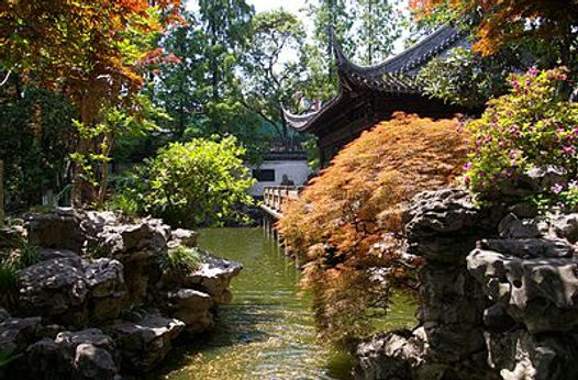
Chinese garden architecture:*
This picture of the Yuyuan Garden in Shanghai (created in 1559) shows all the elements of a classical Chinese garden – water, architecture, vegetation, and rocks.
<F>
islands & promontories of Aegean: *
Spengler placed great emphasis on "homelands" for Cultures, the land sof origin, the fatherlands. He felt this environment tied them to a specific area, with specific character. And it clearly has a major impact ton the Prime Symbol.
The isolation caused by the insular island nature of the Aegean Sea, as well as the mountains of Greece (which also worked to cut off wider communities).- of this he uses to explain the Apollonian tendency towards multiple entities (polis, polytheism).

<G>
broad plains of Franconia, Saxon & Burgundy (map): *
Burgundy: named after a Germanic tribe originating in Scandinavia, 4th century AD settled in Roman Gaul & western regions of the Alps. They caused considerable chaos to the Romans & their allies. Their struggles in the 5th & 6th centuries are the origins of the Nibelungenlied. In 532 they were defeated by the Franks at Autun, their king killed & their lands annexed by the Frankish Empire. No longer independent they took on various shapes for the next 500 years. It was included in Middle Franconia (843) and emerged as the Kingdom of Arles, 933–1378.
Saxony: homeland of the Saxons NW corner of Germany. After the fall of the Roman Empire (476) they remained loosely tied to the Merovingian kings & remained pagan. Their lands were a broad plain, save on the south, where they rose into hills & the low mountainous country of the Harz & Hesse. This low divide was all that separated them from the Franks. In the late 7th century missionaries from England arrived & were met with hostility & killed (695). This reluctance to accept Christianity & propensity to mount raids on their neighbours led to direct conflict with Charlemagne. After a bloody war of attrition (772-804) the Saxons were subdue & forced to convert. The region was incorporated into Franconia (814 Treaty of Verdun- Franconia’s north most region)
Franconia: origins lie in the settlement of the Franks from the 6th century in the area probably populated until then mainly by the Elbe Germanic people in the Main river area; known from the 9th century as East Francia. On the death of Louis the Pious (son of Charlemagne) the Frankish Empire was split into 3. Louis the German, became King of the East Frankish Kingdom (East Francia). This area formed the kernel of the later Holy Roman Empire by way of the Kingdom of Germany enlarged with some additional territories from Lothair's Middle Frankish Realm. These territories eventually evolved into modern Austria, Switzerland and Germany.
see maps Europe 500 and Europe 900.


The topology below shows a rough outline of their extent and the geographic features of the historic regions referred to above. Southern regions of Europe are mountainous, while moving north the terrain descends from the high Alps, Pyrenees and Carpathians, through hilly uplands, into broad, low northern plains, which are vast in the east.
